 Me on the Map is a two-hour incursion which is focussed on students developing a sense of, and appreciation for, their special places in school. By the end of the session, they will understand how symbols can be used on maps to represent familiar features in their environment. Locational language is used by our staff to describe position and movement, and this is modelled and reinforced throughout the session.
The day begins with a general discussion about the uses of different types of maps. A digital story consolidates prior knowledge and promotes student understanding of their part in a bigger world.
Using information from the digital story, students engage in a hierarchy activity where they establish the location of their school in relation to their suburb, Brisbane, Queensland, Australia and planet Earth. Students undertake an exploratory walk around school, where they locate, share and photograph their familiar places and consider how they can be cared for.
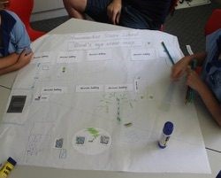
Once back in the classroom, the students are guided by our staff as we work collaboratively in small groups to position photographs and labels of familiar places to create a bird's eye view map of their school.
Prior to the day, we ask that students consider their special places around school before creating meaningful symbols for each. The symbols help to develop the students' sense of identity and belonging, which in turn encourages an awareness of why and how they should look after their familiar place.