Sea-level rise is one of the central facts of our time, as real as gravity. It will reshape our world in ways most of us can only dimly imagine." ― Jeff Goodell, The Water Will Come: Rising Seas, Sinking Cities, and the Remaking of the Civilized World
Program Overview
Sustaining Coastal Communities is a full day excursion which investigates the challenges faced by coastal towns as our climate changes and sea levels begin to rise. These communities are now faced with the very real, and in some cases urgent, problem of whether to stay and adapt, or to retreat.
The day begins with an overview of the issues framed against a changing climate and sea level rise. Students then go on to complete a field sketch of the foreshore area with a view to considering the way in which the area is currently managed, but also its environmental, economic and social value.
Data is collected in two sessions and your students will be divided into two groups. Each group will focus on one street, with a view to data being shared and the students gaining an insight into the effects of future inundation on a wider area.
 Session one: The height of the land will be measured using a dumpy level. This will allow the students to consider how much of the street they are investigating will be affected by flood in the worst-case scenario - namely a king tide and predicted sea level rise by 2100. Measurements are taken along the street and on the foreshore in twenty metre intervals to aid with future spatial mapping.
Session two: A street survey will highlight which houses along the street are capable of being adapted (raised) or not. Distances of twenty metres will be noted on the map. From this, students would be able to map the change in land heights along the street and plot the category of house (under 1.5 metre, above 1.5 metre etc) to show what proportion might be inundated by 2100. In session two, the students will also complete an annotated sketch which illustrates a house that is well adapted to cope with the changed environmental conditions.
In the gathering of secondary data in school, king tide records might show how much of the street has been inundated in the past and sea level rise predictions could show how much of the street will be affected in the future.
Usually this excursion takes place at Sandgate, but the centre is happy to discuss the possibility of transferring this to a location closer to your school.
During this program students undertake a range of activities that include:
- Area sketch to highlight the social, economic and environmental value.
- Coastal elevation data collection (dumpy level).
- Investigation of the types, extent and effects of flooding in the area through the analysis of local flood maps.
- Area survey where students undertake a transect, housing sketch, and housing survey.
- Group discussions session using the iPads as a reference point to look at the ways in which other areas of the world are managing inundation and critically evaluating their suitability in the area surveyed against social, economic and environmental criteria.
Curriculum links
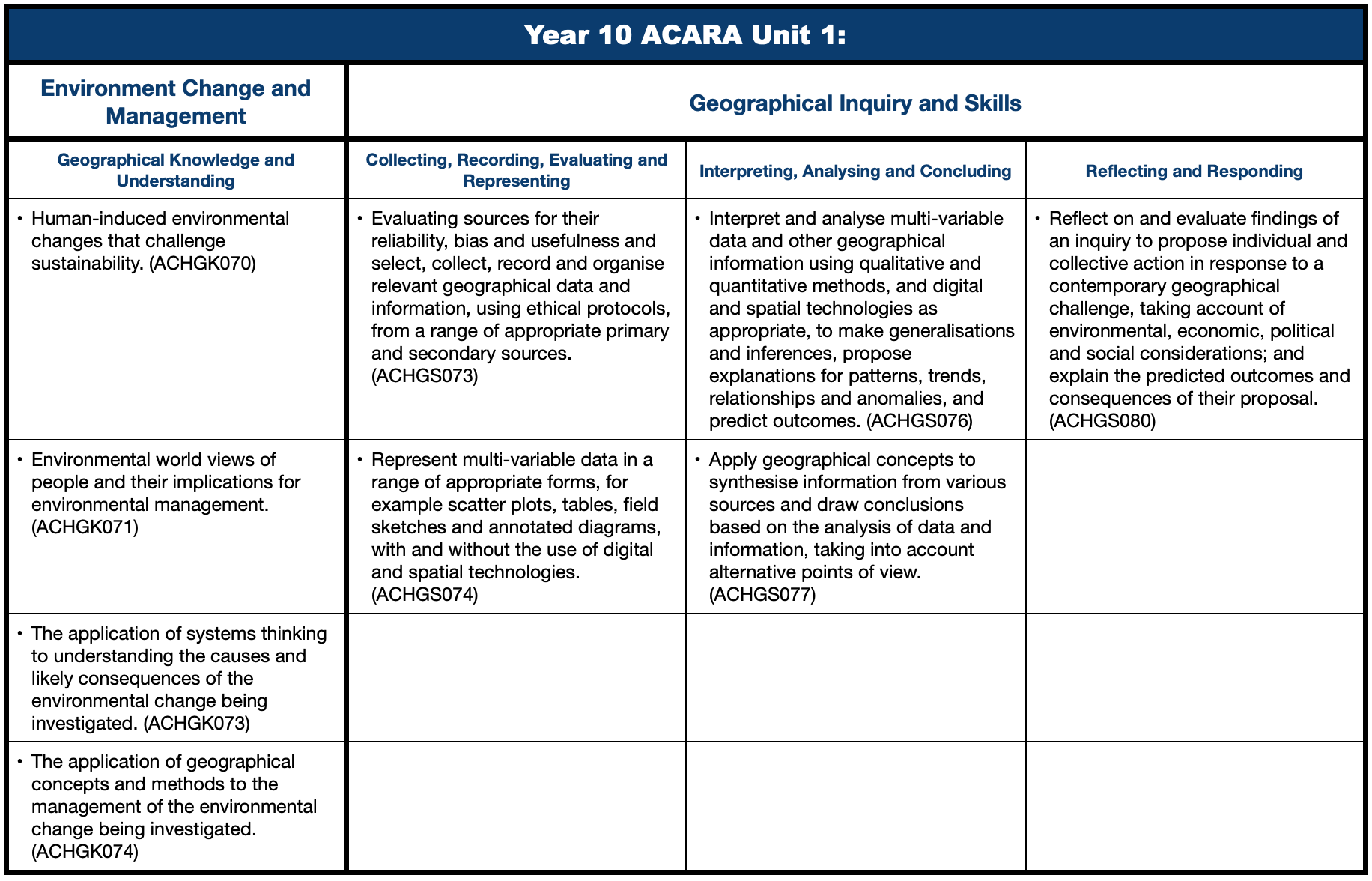
Curriculum Activity Risk Assessment - Year 10 - Sustaining coastal communities
Make a booking!